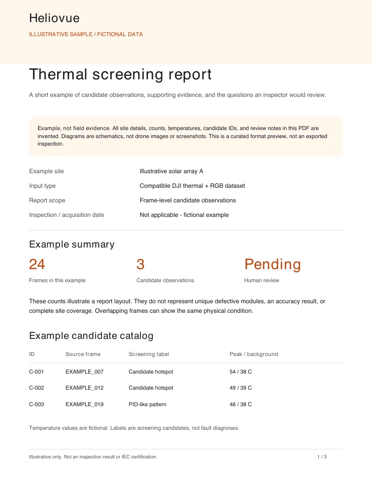
Stop spending several hours turning your flight into a report. Build a solar inspection service around a professional deliverable you can defend: review the evidence and limitations before sharing it with your client.
Bring one existing compatible solar dataset. We’ll help process it free and review the results with you. You keep the deliverables; we ask for one 20-minute feedback call.
From flight to review-ready PDF in one workflow, with an inspector’s review of the evidence before sharing.
Bring original radiometric thermal images and matching RGB photos from one compatible DJI solar flight. We’ll confirm dataset suitability and arrange beta access by email.
Build RGB and thermal maps, then flag candidate hotspots and PID-like thermal patterns. Automated review priorities help focus the inspection; they do not confirm faults.
Inspect available source evidence, record review decisions, and export findings for follow-up. Review the inspection PDF before sharing it.
See dataset requirements and the full workflow
Compare with sorting images and assembling reports by hand
DJI Thermal Analysis Tool 3 vs Heliovue
Raptor Maps vs Heliovue
For solo pilots and small inspection teams adding solar inspections to their services: maps, source imagery, and review tools in one workflow. A qualified inspector still needs to assess the findings.
Decode temperatures from supported DJI radiometric JPEGs and inspect available peak, background, and temperature-difference measurements alongside the source imagery.
Captures processed end to end include DJI Matrice 4T, Mavic 3T (M3T / M3TA) and Mavic 2 Enterprise Advanced. The Franklin M2EA capture validates the pipeline only; a confirmed sensor fault makes its thermal data unsuitable for calibration validation.
Review candidate hotspots and PID-like thermal patterns in separate Review Priority and Monitor queues. These are automated screening results, not a diagnosis or a fault-free verdict.
Explore georeferenced RGB and thermal maps with candidate locations and detected panel outlines. Coverage and panel assignment depend on the capture; some locations remain ambiguous or unassigned.
IEC 62446-3-styled PDF reports bring together candidate findings, thermal imagery, review priorities, and available location information. Review the evidence and limitations before sharing; this is not IEC certification.
For runs with complete candidate evidence, compare thermal and RGB map crops with source-image context. Retain or dismiss a candidate, request field verification, or mark it not assessable, with a review note.
Export eligible candidate catalogs as CSV or GeoJSON with review filters, or download the available evidence archive. Create manual follow-up cases from eligible reviewed candidates. Older captures may need reprocessing to enable evidence review.
Captures processed end to end include Matrice 4T, Mavic 3T (M3T / M3TA), and Mavic 2 Enterprise Advanced. Model support does not guarantee that every dataset will work. The Franklin M2EA capture validates the pipeline only: a confirmed sensor fault makes its thermal data unsuitable for calibration validation.
Bring original radiometric thermal JPEGs and matching RGB photos from one solar flight. Image overlap, capture conditions, metadata, and camera health affect suitability. We confirm suitability by email before arranging beta access; a rendered thermal screenshot is not a substitute for the original files.
The signup form collects team and dataset details, not image files. When you later upload through the product, imagery, embedded flight metadata, and generated maps, candidate catalogs, and reports are stored and processed using Google Cloud and Firebase. Organization access depends on member roles.
You retain ownership of your imagery and processing outputs. Our existing privacy policy says we do not sell personal information. Data is retained while your account is active or as needed to provide the service, and for the purposes described in that policy. Contact contact@4tech.us for access, export, or deletion requests.
Bring one existing compatible solar dataset. We’ll help process it free and review the results with you. You keep the deliverables; we ask for one 20-minute feedback call. Submitting the form requests a conversation; it does not automatically grant beta access.
Review the evidence and limitations first. The IEC 62446-3-styled PDF brings together candidate findings, thermal imagery, review priorities, and available location information. It supports an inspector’s work; it is not IEC certification.
Hotspots and PID-like thermal patterns are candidates for human review. Capture coverage and panel assignment vary, and some locations remain ambiguous or unassigned. No candidates found does not mean a fault-free site. Verify findings before making maintenance, safety, or warranty decisions.
Pilots and inspection teams with an existing solar thermal flight to review. It is not a homeowner self-diagnosis tool, and it does not replace a qualified inspector or field verification.
Share a few details about your team and the existing compatible dataset you’d like us to process.
Built by Andriy Selyutin, a commercial thermal inspection pilot. Why I’m building Heliovue
Keep your dataset ready. We’ll use the email address you submitted to continue the first-flight process.